Airplane Ground Schools
Knowledge of Flying is Our passion.
Serving the General Aviation Community
|
|
This chapter introduces the various classifications of airspace and provides information on the requirements to operate in such airspace. For further information, consult the Aeronautical Information Manual (AIM) and 14 CFR parts 71, 73, and 91. The two categories of airspace are: regulatory and non- regulatory. Within these two categories there are four types: controlled, uncontrolled, special use, and other airspace.
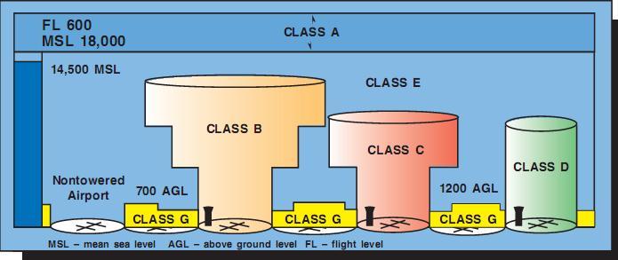
[Figure 13-1. Airspace profile.]
Figure 13-1 presents a profile view of the dimen- sions of various classes of airspace.
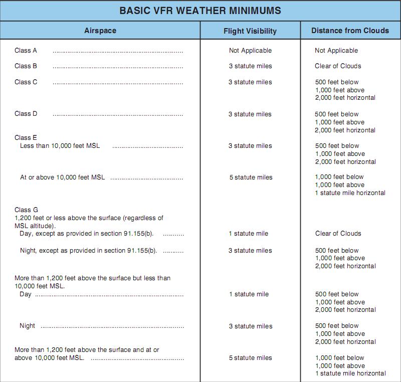
[Figure 13-2.Visual flight rule weather minimums.]
Figure 13-2 gives the basic weather minimums for operating in the different classes of airspace.
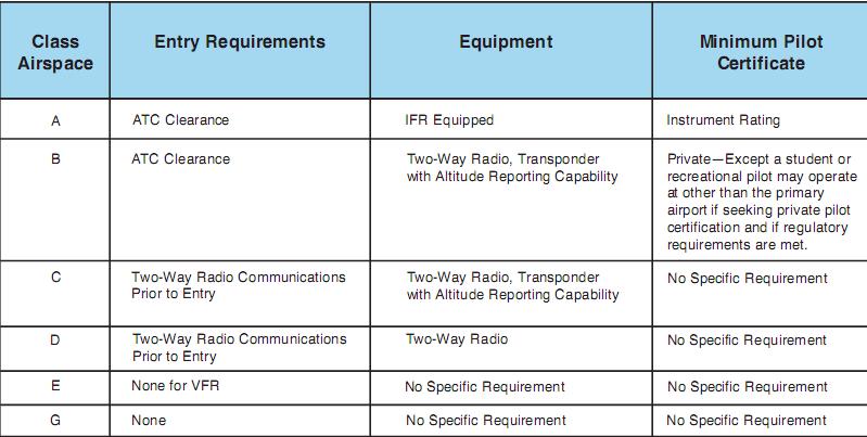
[Figure 13-3. Requirements for airspace operations.]
Figure 13-3 lists the operational and equipment requirements. It will be helpful to refer to these figures as this chapter is studied. Also there are excerpts from sectional charts in Navigation, that will show how airspace is depicted.
CONTROLLED AIRSPACE
Controlled airspace is a generic term that covers the different classifications of airspace and defined dimensions within which air traffic control service is provided in accordance with the airspace classification. Controlled airspace consists of:
• Class A
• Class B
• Class C
• Class D
• Class E
CLASS A AIRSPACE
Class Aairspace is generally the airspace from 18,000 feet mean sea level (MSL) up to and including FL600, including the airspace overlying the waters within 12 nautical miles (NM) of the coast of the 48 contiguous states and Alaska. Unless otherwise authorized, all operation in Class A airspace will be conducted under instrument flight rules (IFR).
CLASS B AIRSPACE
Class B airspace is generally the airspace from the surface to 10,000 feet MSL surrounding the nation’s busiest airports. The configuration of Class B airspace is individually tailored to the needs of a particular area and consists of a surface area and two or more layers. Some Class B airspace resembles an upside-down wedding cake. At least a private pilot certificate is required to operate in Class B airspace; however, there is an exception to this requirement. Student pilots or recreational pilots seeking private pilot certification may operate in the airspace and land at other than specified primary airports within the airspace if they have received training and had their logbook endorsed by a certified flight instructor in accordance with Title 14 of the Code of Federal Regulations (14 CFR) part 61.
CLASS C AIRSPACE
Class C airspace generally extends from the surface to 4,000 feet above the airport elevation surrounding those airports having an operational control tower, that are serviced by a radar approach control, and with a certain number of IFR operations or passen- ger enplanements. This airspace is charted in feet MSL, and is generally of a 5 NM radius surface area that extends from the surface to 4,000 feet above the airport elevation, and a 10 NM radius area that extends from 1,200 feet to 4,000 feet above the air- port elevation. There is also an outer area with a 20 NM radius, which extends from the surface to 4,000 feet above the primary airport, and this area may include one or more satellite airports.
CLASS D AIRSPACE
Class D airspace generally extends from the surface to 2,500 feet above the airport elevation surround- ing those airports that have an operational control tower. The configuration of Class D airspace will be tailored to meet the operational needs of the area. CLASS E AIRSPACE Class E airspace is generally controlled airspace that is not designated A, B, C, or D. Except for 18,000 feet MSL, Class E airspace has no defined vertical limit, but rather it extends upward from either the surface or a designated altitude to the overlying or adjacent controlled airspace.
UNCONTROLLED AIRSPACE CLASS G AIRSPACE
Uncontrolled airspace or Class G airspace is the portion of the airspace that has not been designated as Class A, B, C, D, or E. It is therefore designated uncontrolled airspace. Class G airspace extends from the surface to the base of the overlying Class E airspace. Although air traffic control (ATC) has no authority or responsibility to control air traffic, pilots should remember there are VFR minimums which apply to Class G airspace.
SPECIAL USE AIRSPACE
Special use airspace exists where activities must be confined because of their nature. In special use airspace, limitations may be placed on aircraft that are not a part of the activities. Special use airspace usually consists of:
• Prohibited Areas
• Restricted Areas
•Warning Areas
• Military Operation Areas
•Alert Areas
• Controlled Firing Areas
PROHIBITED AREAS
Prohibited areas are established for security or other reasons associated with the national welfare. Prohibited areas are published in the Federal Register and are depicted on aeronautical charts.
RESTRICTED AREAS
Restricted areas denote the existence of unusual, often invisible hazards to aircraft such as artillery firing, aerial gunnery, or guided missiles. An aircraft may not enter a restricted area unless permission has been obtained from the controlling agency. Restricted areas are depicted on aeronautical charts and are published in the Federal Register. Class Airspace Entry Requirements Equipment Minimum Pilot Certificate A ATC Clearance IFR Equipped Instrument Rating B ATC Clearance Two-Way Radio, Transponder with Altitude Reporting Capability Private—Except a student or recreational pilot may operate at other than the primary airport if seeking private pilot certification and if regulatory requirements are met. C Two-Way Radio Communications Prior to Entry Two-Way Radio, Transponder with Altitude Reporting Capability No Specific Requirement D Two-Way Radio Communications Prior to Entry Two-Way Radio No Specific Requirement No Specific Requirement No Specific Requirement No Specific Requirement No Specific Requirement E G None for VFR None Figure 13-3. Requirements for airspace operations.
WARNING AREAS
Warning areas consist of airspace which may contain hazards to nonparticipating aircraft in international airspace. The activities may be much the same as those for a restricted area. Warning areas are estab- lished beyond the 3-mile limit. Warning areas are depicted on aeronautical charts.
MILITARY OPERATION AREAS
Military operation areas (MOA) consist of airspace of defined vertical and lateral limits established for the purpose of separating certain military training activity from IFR traffic. There is no restriction against a pilot operating VFR in these areas; how- ever, a pilot should be alert since training activities may include acrobatic and abrupt maneuvers. MOAs are depicted on aeronautical charts.
ALERT AREAS
Alert areas are depicted on aeronautical charts and are to advise pilots that a high volume of pilot training or unusual aerial activity is taking place.
CONTROLLED FIRING AREAS
Controlled firing areas contain activities, which, if not conducted in a controlled environment, could be hazardous to nonparticipating aircraft. The difference between controlled firing areas and other special use airspace is that activities must be suspended when a spotter aircraft, radar, or ground lookout position indicates an aircraft might be approaching the area.
OTHER AIRSPACE AREAS
“Other airspace areas” is a general term referring to the majority of the remaining airspace. It includes:
• Airport Advisory Areas
•Military Training Routes (MTR)
•Temporary Flight Restrictions
• Parachute Jump Areas
• Published VFR Routes
• Terminal Radar Service Areas
• National Security Areas
AIRPORT ADVISORY AREAS
An airport advisory area is an area within 10 statute miles (SM) of an airport where a control tower is not operating, but where a flight service station (FSS) is located. At these locations, the FSS provides advi- sory service to arriving and departing aircraft.
MILITARY TRAINING ROUTES
Military training routes (MTR) are developed to allow the military to conduct low-altitude, high- speed training. The routes above 1,500 feet AGL are developed to be flown primarily under IFR, and the routes 1,500 feet and less are for VFR flight. The routes are identified on sectional charts by the designation “instrument (IR) or visual (VR).”
TEMPORARY FLIGHT RESTRICTIONS
An FDC NOTAM will be issued to designate a tem- porary flight restriction (TFR). The NOTAM will begin with the phrase “FLIGHT RESTRICTIONS” followed by the location of the temporary restriction, effective time period, area defined in statute miles, and altitudes affected. The NOTAM will also contain the FAA coordination facility and telephone number, the reason for the restriction, and any other informa- tion deemed appropriate. The pilot should check the NOTAMs as part of flight planning. Some of the purposes for establishing a temporary restriction are:
• Protect persons and property in the air or on the surface from an existing or imminent hazard.
• Provide a safe environment for the operation of disaster relief aircraft.
• Prevent an unsafe congestion of sightseeing aircraft above an incident or event, which may generate a high degree of public interest.
• Protect declared national disasters for humanitarian reasons in the State of Hawaii.
• Protect the President, Vice President, or other public figures.
• Provide a safe environment for space agency operations.
PARACHUTE JUMP AREAS
Parachute jump areas are published in the Airport/Facility Directory. Sites that are used fre- quently are depicted on sectional charts.
PUBLISHED VFR ROUTES
Published VFR routes are for transitioning around, under, or through some complex airspace. Terms such as VFR flyway, VFR corridor, Class B airspace, VFR transition route, and terminal area VFR route have been applied to such routes. These routes are generally found on VFR terminal area planning charts.
TERMINAL RADAR SERVICE AREAS
Terminal Radar Service Areas (TRSA) are areas where participating pilots can receive additional radar services. The purpose of the service is to provide sep- aration between all IFR operations and participating VFR aircraft. The primary airport(s) within the TRSA become(s) Class D airspace. The remaining portion of the TRSA overlies other controlled airspace, which is normally Class E airspace beginning at 700 or 1,200 feet and established to transition to/from the en route terminal environment. TRSAs are depicted on VFR sectional charts and terminal area charts with a solid black line and altitudes for each segment. The Class D portion is charted with a blue segmented line. Participation in TRSAservices is voluntary; however, pilots operating under VFR are encouraged to contact the radar approach control and take advantage of TRSA service.
NATIONAL SECURITY AREAS
National security areas consist of airspace of defined vertical and lateral dimensions established at locations where there is a requirement for increased security and safety of ground facilities. Pilots are requested to voluntarily avoid flying through these depicted areas. When necessary, flight may be temporarily prohibited.
(Courtesy FAA)
Copyright © 2008 AirplaneGroundSchools.com | All Rights Reserved
Design G. Wolfgang | W3C XHTML 1.0 | W3C CSS 2.0
Courtesy Open Web Design![]() Thanks to Florida Vacation Homes
Thanks to Florida Vacation Homes